Now that the bridge over the Mulgrave River to the Wooroonooran National Park has been repaired, anglers can easily fish the upper sections of the river. In the July ‘05 issue of QFM I wrote about canoeing the sections from the bridge down and how the wet season is the ideal time to explore the upper reaches.
The trip down from the National Park camp ground to the Wooroonooran Bridge is a comfortable half-day paddle with plenty of time to stop and fish the better holes. The Mulgrave was at the lowest level possible for us not to be carrying the canoes regularly. We only had to alight twice – once to walk the canoe over a shallow section about 10m long and again to avoid a tricky section of rapids.
Last year it was a father and son trip, so this time Terry McClelland and I decided to go on a father and daughter outing. Terry’s 12-year-old Shannon and my 11-year-old Ally get on famously so it was an ideal combination. The only obstacle was Shannon’s phobia of insects. A rainforest stream in the middle of the wet season is prime marsh fly country, so Terry’s only stipulations were, “bring the Bushman repellent (easy) and nothing blue (not so easy)”.
Marsh flies are attracted to blue, as anyone who has encountered these creatures would know. I can recall being on Fraser Island as a teenager, in a blue tent, and fighting off the dreaded brown bombers with a diving fin as they landed in their hundreds on the tent flaps. Terry was very keen to get Shannon into more outdoor activities and was worried that the marsh flies could make this her final canoe trip.
At first I thought Terry’s request for nothing blue would be no problem but it turned out to be an impossible task. It seemed as though everything I owned was blue. Even the only large dry bag I had was blue! I ended up placing it inside a black plastic bag, but every time I opened the dry bag during the trip the marshies swarmed. Terry has always considered the brown bombers when purchasing outdoor gear and tried to avoid anything blue. It can take some searching at times to find items of camping/outdoor gear in other colours.
We met at the turn-off to the Goldsborough Valley at 7am and I left my car at Wooroonooran Bridge on the way to the National Park campground. The 6km from the bridge to the National Park campgrounds is gravel but easily passable in a 2WD. About 100m past the campground is the best river access and we were soon on the water, after Shannon had covered herself with Bushman Plus.
The low river height meant the rapids were fun without being exhilarating and with two novices aboard it was probably just as well.
The scenery in the upper section is breathtaking where the river rapidly descends the valley. There are a lot more rapids in this stretch compared to the two below, with the holes much smaller.
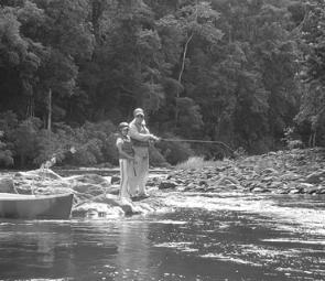
While trolling was the preferred option in the lower reaches, it was better to stop and flick the base of the rapids on the next section of the river. No sooner would you be set into a good trolling/paddling rhythm than it would time to wind in for the next section of white water. The best angling option was to work from the canoe or alight onto the bank at the base of the rapids that flow into the deeper holes and work the drop-offs and eddies on the edges of the flowing water. Sooties, jungle perch and mangrove jack all sit in ambush waiting for a feed to drift past in the current.
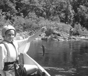
The water was crystal clear this trip, which meant the fish were hard to come by on lures. Shannon caught a heap of small sooties on a handline using garden worms. Ally caught the biggest fish of the day when she trolled up a tarpon, which put up a spectacular aerial display on its way to the canoe. With a little more height in the river, and the accompanying colour in the water, I imagine the luring would be excellent, as it was the previous year in the lower sections, but that will have to wait on more rain.
The girls had such a ball they are joining Terry and I, and our two sons, along with their mothers, on the first two days of a seven-day trip down the Mitchell River.
Fact Sheet:
Turn west off the Bruce Highway, onto the Gillies Range Road, at Gordonvale (7km to Goldsborough Valley Rd).
Wooroonooran National Park campground is 17km up the Goldsborough Valley Road from the Gillies Range Road.
The last 6km from Wooroonooran Bridge is dirt, but easily passable by 2WD in all but heavy weather.
The river needs a minimum of .8m at The Fisheries (max 1.5m) and minimum of 1.85m at Peets Bridge (max 2.5m). Check www.bom.gov.au/weather/qld , Weather Observations, All Latest Queensland Weather Observations , Queensland Rainfall and River Heights , Herbert, Tully, Johnstone, Barron, Daintree , and scroll down to Mulgrave-Russell to check the river height.
Check the radar before departure for any signs of storms in the headwaters. These can result in flash flooding and dangerous conditions. Visit www.bom.gov.au/weather/qld , Weather Observations, Radar Images (Rainfall location and intensity), and click on Cairns.
Check the rainfall over the past 24 hours in the headwaters for any indication of rising streams. www.bom.gov.au/weather/qld , Weather Observations, All Latest Queensland Weather Observations , Queensland Rainfall and River Heights , Herbert, Tully, Johnstone, Barron, Daintree , and scroll down to Rainfall Bulletins, below River Heights. Click on 3hrs and scroll down to Mulgrave-Russell to get three hourly rainfall figures for the previous 24hrs.
MAP:
Use the same location map as printed in the July 05 issue (P 34) about the lower sections of the Mulgrave. See if the original map extends up past (South) The Fisheries.
Getting out to stretch your legs and luring the base of the rapids is another great way to work a hole.
Reads: 2715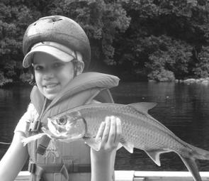
Ally Lavalle-Smith was thrilled with her tarpon, which she captured on a trolled Prawnstar Jr El Natural.

Working the base of rapids from the canoe is the best way to fish a hole.
Shannon McClelland had a ball catching small sooties on a handline, using garden worms for bait.
or 5