Certainly most of the top fishing opportunities in and around Hervey Bay and Sandy Straits need to be accessed by boat. Each day in reasonable conditions boats of wide range of capabilities are seen leaving the ramps heading for favoured destinations.
There were days that some of us can remember when access to a boat was something of a luxury and more anglers were restricted to land-based venues. Today, while more anglers per capita are keen to head for the wide blue yonder, there are plenty of options for the land-based angler. With a general decline in fish resources across the board these land-based spots may or may not be as productive as they have been in times past.
The continually growing city of Hervey Bay extends along the bay for which it is named from its northern outpost of Toogoom to River Heads at the mouth of the Mary River. This month we will see what opportunities are to be had at the northern end of the bay’s coastline.
Once a sleepy little fishing village on the banks of Beelbi Creek, Toogoom is fast becoming part of Hervey Bay suburbia. Fortunately it hasn’t lost much of its earlier charm, as there are still plenty of fish to be had within the creek and on the sand flats south of the mouth.
Coming from the south along the Bruce Highway, turn right at Torbanlea, then right again onto Hervey Bay road. A few kilometres further on turn left onto Toogoom road. If coming from Hervey Bay, take Burrum Heads road and turn off to the right just north of Craignish or continue onto its intersection with Torbanlea-Toogoom road. All roads take you into the epicentre of Toogoom, the boat ramp and shopping centre.
Beelbi Creek drains a small area of hinterland, becoming narrow and mangrove-lined before reaching its estuary and entering the sea. It is most accessible along the southern foreshores of the estuary. On the lowest tides it is reduced to a series of shallow channels and pools. Rather than having a totally sandy base, the creek has plenty of structure in the way of shell banks and rocks, particularly noticeable in the lower estuary that is lined with fishing cottages and more modern dwellings. The creek enters the bay having carved a variable path through the sand flats that dominate the foreshores. Upstream, the creek is narrow and mangrove lined. There is little easy access to the upper narrow mangrove lined reaches. However it is possible to park off Burrum Heads road just south of the bridge over the creek where bream, javelin and the occasional jack is taken. This is also a great spot to bury a crab pot for a few hours.
Further downstream, the estuary section is accessed from within the built up area. From the centre of town, Moreton Street runs west between two reaches of the creek. By turning onto Beelbi Place there is reasonable access to this section of the estuary. The steep snaggy bank is likely to produce bream and flathead with jacks also likely during the warmer months. Moreton Street comes to a dead end along the east-facing bank of the estuary. Depending on the state of the tide, there are plenty of good features to be checked out from here. With the majority of land to the west of this point being private property, access around the bend of the creek isn’t easy. In this lower estuary, flathead, bream and whiting are the main target species. Although not always highly esteemed by anglers, yellowtail pike can produce some good sport on light gear. They are particularly partial to a wide range of plastics, and thanks to their dentistry, are quite good at destroying them as well. The humble yellowtail pike, as well as producing excellent cut baits, isn’t bad eating either.
Just downstream from the boat ramp and observation pier, excellent rock, gravel and shell features occupy the majority of the creek bed. This is premium flathead country, particularly towards the bottom of a big tide and again on the early flood. On a falling tide it is possible to follow the creek out along the banks. Of course flathead and bream are likely captures but this is where most of the sand whiting are taken. Whiting can be very unpredictable. On some days, they bite well on the ebb, and on others, you need to wait for the flood to get them interested. We must not forget the vast areas of flats that extend from here south towards Point Vernon, but this will be for another column.
Leaving the mainland and heading across to Fraser Island, the news is that there have been few complaints about the current tailor season. The general opinion is that the season so far has not been spectacular but there have still been enough good fish to keep everyone happy. Last month, the season had yet to pick up so anglers visiting this month should be in for some fun. With the headlands being closed for the last two months, October will see plenty of activity on the northern face of Indian Head, as well as Waddy Point. There have been plenty of mulloway taken right along the eastern beaches, with a mixture of metre plus fish and juveniles. Anglers are reminded that the legal minimum length of mulloway is 75cm, and the bag limit of 2. Depending on its condition, a just legal mulloway weighs between 3.5 and 3.8 kg. Anglers targeting during recent evenings have been frustrated by the abundance of sharks, ones with big teeth as well as ones without.
The ocean beaches continue to rebound following the devastating conditions of the early months of the year. There are still some trouble spots, particularly where sand is not fully built up around exposed coffee rocks. Happy Valley to Moon Point road is reported to be closed, so anglers who like to visit the western beach for excellent whiting fishing at this time of the year, might need to consider the Woralie track, now the only way of reaching the western beach from the east.
Reads: 13445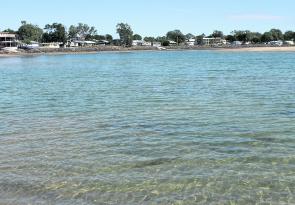
Great flathead features at the mouth of Beelbi Creek.

Beelbi creek further upstream – steep banks and snags.