Facts
MAPS: 1
NOTES:
What a spot! Most people still call Southern Pumicestone a hidden paradise, but over the past few years the waterways have come alive. It’s gone from a few tinnies running around to a plethora of water activities attracting visitors from all across the state. The main recreation is still fishing, because it’s heaven for most species.
Situated just over 60 minutes, or 67km north, from Brisbane CBD. You can take the Bribie Island exit (Exit 85) off the Bruce Highway and head east through the township of Ningi where you will spot the water briefly on the left through the trees. This is Ningi Creek, the closest creek to Bribie but on the main land side of the Island.
Ningi Creek is one of the most accessible creeks on the passage with tidal influence causing no problems and channel markers leading you through the mouth and beyond. As you explore the mouth of this creek on a low tide you will soon realise why anglers love this area so much.
I strongly recommend exploring most areas on a low tide, take a mental note and don’t be scared to ask a local a few questions. You may be surprised some of the locals around here may teach you in 10 minutes what your can’t learn in a week on the water my yourself.
As you hit the Bribie Bridge I guarantee all your life worries will be left behind. Take a quick look to the right you will see the Military Jetty, a haven for fish and anglers, or maybe just a lazy afternoon at a cafe or restaurant with a coldie contemplating the days ahead on the water..
To get there, as you hit Bribie Island keep going through to the first round-about continue around it as though you want to head back to the bridge and turn left just before you hit the bridge, and then follow the Esplanade.
When you travel along the Esplanade you will cross a small bridge, this is a man-made canal creek called The Lock – famous for mangrove jack.. You can’t enter this canal unless you own a home there, but from the mouth to the actual locked gates (hence the name) is home to some of the nastiest mangrove jack the island has to offer, along with bream and other species. This is only approximately 300m of waterway, but don’t be fooled, it holds plenty and is best fished from land. As you enter The Lock waterway to your left is a man-made bathing beach and play ground for the kids with BBQs.Good whiting and flathead are taken from this bathing beach on a regular basis.
Keep driving and on the left is a caravan park with full water views directly into the Passage. There is a boat ramp very close by. Keep going and you will find Military Jetty to your right, which has multiple areas to eat, drink or just relax, with a Bowls Club, RSL Club, Fast food, fish and chips, tackle, ice cream and much more.
This is an awesome jetty, with pontoons that have limited time mooring for boats; this ensures anglers have the main run over the area. I can only suggest that as an angler, target this area very early or very late before the crowds set in as it is a popular spot for jet skis and swimmers.
The area is a haven for fish as the jetty enters into 25ft of water and is the main thoroughfare for fish like mulloway, bream, juvenile snapper, flathead, cod, parrot, grassy sweetlip, Moses perch, mackerel and tailor entering and leaving the Passage. Remember that tailor are seasonal from June through until August.
Look to the west of the jetty onto the main land on the opposite side of the Passage and this is where you have some of the best sand crabbing grounds the Passage has to offer and all the way north to the bridge and beyond. You have Moreton Bay out to the left best suited to craft 5m plus.
Keep going south from the jetty and you will find the famous Red Beach – a deadly area for targeting whiting from the beach.
The bridge is a hot spot for juvenile snapper and mulloway, although it is very hard to fish on a full flowing tide. But with a little bit of thought it can be done. Fish closer to the island or main land on the full flow period and move into the middle of the bridge as it slows and just add or remove lead as needed. I recommend using a little heavier leader than you would normally as these pylons are covered in oysters.The fish will towel you up in an instant if you give them a chance.
North of the Bribie Bridge is Pacific Harbour (take a left at the second round-about off the bridge), this will lead you to the a canal system called Pacific Harbour with multiple areas to fish land-based and out of the wind; and all tides will produce fish.
Just follow your nose, driving around in your car through the canal homes there are multiple areas for the land-based anglers. You are likely to pull juvenile snapper, bream, trevally, flathead, Moses perch, jacks and mud crabs, among other species from these waters.
Situated directly at the mouth of Pacific Harbour is the famous area called The Ripples. It is very easy to find with your sounder as it is a large area and jumps from approximately 25ft of water up into about 5ft of water and as the tide is moving it can be seen with the naked eye eye. as the water boils and takes on a rough surface appearance; hence its name, The Ripples. Juvenile snapper, bream and sweetlip are the main targets in this area.
Just north of there is the Avon Wreck, which is visible on the lower part of the tides from low up to approximately two-thirds of a tide before it becomes submersed and a little dangerous. It’s home to some decent whiting and bream by the bucket load. There is an island directly behind the wreck looking northward that is surrounded by relatively deep water; this area is known to hold good fish.This is one example of the beauty of the Passage with its vast array of waterways you can spend many weekends exploring.
If you continue east across the island you can discover Woorim, the surfside of the island, which is a short 10 minutes east from the jetty.
To the north of Woorim is the 4WD beach access and you can drive and fish all the way north to the Caloundra bar. Ensure you purchase a Beach Access Permit to drive on the beach. These can be purchased from Ningi Bait and Tackle, the Bongaree Caravan Park or online.
Camping is permitted on the beach, however ensure you book in advance as there is a cap on the number of campers. No facilities are provided. There are 64 designated beach campsites sprinkled along this section of beach. Dart, whiting, flathead and bream can easily be taken from the beach and if you’re lucky and geared up you may take a tune or two straight off the beach.
Heading about 10 minutes north of the bridge and directly east across from the township of Toorbul is White Patch. This area is also accessible by car and can be fished from land. At the second roundabout off the bridge follow the White Patch signs to the left, follow this road north to the end and just before you hit the unsealed section of road is the suburb of White Patch.
If you keep following this gravel road it leads to the inland tracks of the island and camp grounds on the Passage. These tracks are 4WD only.
White Patch is a popular mooring ground for big boats in bad weather as it is very well protected from northerlies and northeast/easterlies. The Patch holds juvenile snapper, bream, flathead the odd mulloway and sand crabs. Continue to the northwest into the end of this gutter (the locals call it the back gutter) it peters out into very shallow water but still very fishy country with the odd mud crab taken from this area.
Across the Passage to the sleepy old town of Toorbul you have parks, BBQs, food, ice, drinks, boat ramps and a caravan park. Further north of Toorbul is Elimbah Creek, home to some awesome whiting fishing and mud crabbing. This is situated on the mainland side of the Passage.
If you head directly from Elimbah Creek mouth east over to Bribie you will find Gallaghers Camp Ground, home to only six campsites at any one time. The bank that runs north and south along the front is called Gallaghers Gutter, a perfect fishing spot for bream, whiting, flathead and juvenile snapper.
Further north you have Poverty Creek Camp Ground. It has a maximum of 12 camp sites at any one time. This camp is nestled directly at the mouth of Poverty Creek. This creek is a half tide plus access creek and is only small, but the mud crabs love it. Directly out the front you can angle whiting, flathead and bream.
The township directly west from Poverty Campground is Donnybrook, where you can get supplies, such as food, fuel, ice, bait, tackle and beer. There is a caravan park and bowls club, where you can get a great meal.
The gutter surrounding Donnybrook is Dunlops Gutter; it is home to most estuary species. I have seen anglers anchor their boat 15m directly out from the boat ramp and catch good sized bream. I would not recommend it as the boat ramp can get very busy and you could easily find yourself in a situation where it could get ugly fast – but it does hold fish.
The small jetty in Donnybrook is ideal for land anglers where you will catch loads of prawns around February to March, as they migrate through the area. This jetty drops into the gutter at the end where you can tangle with bream, grunter, whiting, flathead and even the odd mulloway, not to mention the crabs. This jetty is being refurbished at the moment and is a no entry area but is soon to be reopened.This area is still very much worth the trip, just fish off the boat ramp or surrounding banks.
Follow the channel markers north approximately 5 minutes and you have Glasshouse Mountains Creek, better known as Glassy Creek. Here you will find mud flats that hold mud crabs, flathead, whiting, bream and grunter. Don’t forget the prawns when they run, this creek is one of the best, some locals won’t be happy that I told you that, but it’s true.
Look north east from here and you will see a very nice little white beach; this is Mission Point Camp Ground, this is situated on Bribie but. It canIt can only be accessed by boat and the closest boat ramp is Donnybrook. It has a great western view towards the Glasshouse Mountains and is very protected and calm. This campground has a drop toilet but not much else, so you need to boat all your needs over including freshwater. On weekdays when it is quiet you can get wild brumbies roaming the campground but once the weekend arrives you may not be so lucky, as they are quite shy.
The fishing and crabbing off this bank can be very good at times. Don’t be fooled by the nice white beach, this beach drops off into a deep coffee rock ledge home to the hardest fighter the Passage has to offer – the mighty mangrove jack. They have been taken land-based along this strip of hidden rock on multiple occasions. The crabbing around here can be good at times especially when there is a bit of fresh running. Head north from here towards Caloundra, you will find Hussy Creek, Coochin Creek and Bells Creek all onyour left. These creeks mentioned are famous for whiting, jacks and mudcrabs. Your best bet if wanting to enter these areas is to grab yourself a copy of the ‘Beacon to Beacon ‘directory sold at most larger tackle stores.
Now if you want to access the Passage via the towns of Toorbul or Donnybrook, you can do so by taking the very next exit after the Bribie Island exit, and then just follow the Donnybrook/Toorbul signs until you hit the water.
All these camp grounds and areas I have mentioned hold good numbers of sand crabs most of the time. If you plan to camp at these areas you must take your rubbish home with you. Bribie Island has all your needs and more from Woolworths, petrol stations, bakeries, and doctors and more; although it’s quiet and peaceful I would nearly class it as a small city.
The further you head north up the Passage the more remote it becomes. You can travel north via the passage all the way to Caloundra, following the channel markers all the way. But it’s a long stretch of remoteness until you get there.
I have only scratched the surface of what Pumicestone Passage has to offer. I have fished it for 23 years and still haven’t seen it all. I recommend you come and explore a not so little piece of paradise that I have nestled at my back door. I don’t plan on leaving any time soon and for very good reason – it is truly a piece of paradise.
For camping permits and further information on camp locations call 131304 or go to www.nprsr.qld.gov.au
MAJOR EVENTS
The region is rapidly gaining a reputation as an exciting destination for events and celebrations.
A complete list of events is available on www.moretonbay.qld.gov.au
JULY
Abbey Medieval Festival
1-63 The Abbey Place, Caboolture
P: (07) 5495 1652
www.abbeymuseum.asn.au
Farm Fantastic
Pumicestone Road, Caboolture
P: (07) 5490 1440
www.farmfantastic.com
Jetty 2 Jetty Fun Run
Corner Woodcliffe Crescent & Oxley Avenue, Woody Point
www.j2j.com.au
Heritage Fair
Caboolture Historical Village
280 Beerburrum Road, Caboolture
P: (07) 5495 4581
www.historicalvillage.com.au
Brisbane CDI
(International Dressage Event)
Queensland State Equestrian Centre
Beerburrum Road, Caboolture
P: 0412 753 512
www.qlddressagefest.com
AUGUST
What’s Cooking in the Gardens
George Street, Redcliffe
P: (07) 3205 0555
www.moretonbay.qld.gov.au
SEPTEMBER
Mega Motor Show
Caboolture Historical Village
280 Beerburrum Road, Caboolture
P: (07) 5495 4581
www.historicalvillage.com.au
Celebrate Redcliffe Festival
Redcliffe Parade, Redcliffe
P: (07) 3205 0555
www.moretonbay.qld.gov.au
DECEMBER
Woodford Folk Festival
Woodrow Road, Woodford
P: (07) 5496 1066
www.woodfordfolkfestival.com
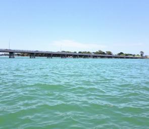
Bribie Island Bridge is famous for juvenile snapper and mulloway.

On of the pontoons off the edge of the Military Jetty. This pontoon has ample room for anglers.
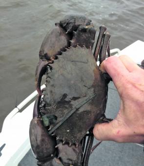
What a beauty! A nice rusty buck taken out of the back gutter.
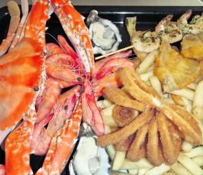
Head to Savige’s Seafood at Bongaree for the best fish and chips on Bribie Island.

Military Jetty at Bribie Island is one of the best land-based positions for targeting fish. Just get up early and beat the crowds.

Mission Point Camp Ground is just north of Donnybrook.
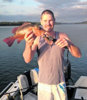
A small mangrove jack fished from the depths of Pumicestone Passage of soft plastics.
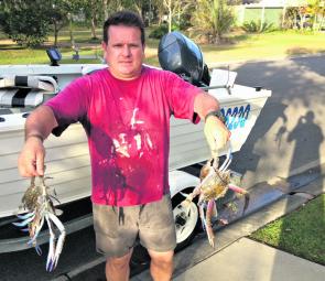
Toorbul local taking a tasty feed of sand crabs home for the family.
A family day out on the Passage yields many flathead. This one was taken on a hardbody lure by the kids –their smiles say it all!
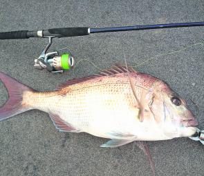
A typical-sized snapper taken off the ripples on soft plastic. Perseverance was the key!

A typical family BBQ by the Passage. What a day, what a sunset! This is living.
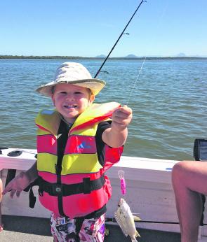
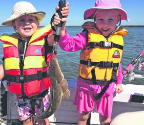
More kids, more fish, more water. The Passage is a great calm water location for the littlies.