Over the last couple of years I have put together information about particular fishing spots along Fraser Island’s western coast beaches; all of which can be accessed by road from the eastern side of the island with most located between Moon Point and Wathumba Creek.
In the following, I will look at these western beach venues collectively.
Firstly, it needs to be clear that more than half of the island’s western coast is devoid of beach. From Hook Point to Moon Point the island is fringed by mangrove forests, sand and mud flats, and estuary mouths – hardly shores suited to vehicular access. In fact it is illegal to attempt to drive on this stretch of coast. Believe it or not, some idiots have tried with inevitable consequences.
North of Moon Point, the sandy beaches are trafficable but from Wathumba Creek north to Rooney Point and east to the Sandy Cape lighthouse track, the beach is totally out of bounds, just another example of how government legislation is effectively locking people out of remote parts of the island. However, I will be looking at those beaches that are open to traffic between Moon Point and Wathumba Creek.
My first experiences of the western beach came in the late sixties when it became part of our regular journeys from Hervey Bay to Waddy Point. Having made the bay crossing to Moon Creek, we would transfer to 4WD for the trip up the beach to Wathumba Creek, then across the island to Orchid Beach and the huts at Waddy Point. Our host, Keith Wieden left a lasting impression on me in the way he handled the various idiosyncrasies of that western beach. On such a trip we were likely to be the only vehicle on the beach in a week, a situation which demanded extreme care. When driving on the western beach, even though I am likely to have accompanying vehicles, I still follow those same lessons learned in those early years. More on this a little later.
Daily barge services between Urangan and Moon Point operated from the early eighties until very recently. Initially barges worked the tides so that both arriving and departing vehicles would have the low water to traverse the beach. In these years, the favoured means of reaching Waddy Point, Orchid Beach and points further north was by using the Moon Point barge. Those were the days when the Middle Rocks jump-up was more than a challenge for the vehicles of the day. With this jump-up having been boarded and better maintained, this is no longer a problem for vehicles heading beyond Middle Rock. Unfortunately more recent services ran to a timetable, one not often convenient for travelling the beach.
Today there is no regular barge service to Moon Point. This means that vehicle access to the western beach can only be from the ocean beach.
There are just three ways of crossing the island.
The most northerly is from Orchid Beach to Wathumba Creek. Here is the only official camping ground with some amenities. Although a track across a mud flat and through a steep-sided creek was part of the regular route from Moon Point to Orchid Beach, access from the camp ground to the beach is not permitted, and for well founded reasons.
The shallow Wathumba Creek is a great place to target whiting, bream, flathead and other estuarine species. A reminder that Wathumba and other locations along the western beach often have a midge problem, so it is wise to be suitably prepared.
The Woralie Road leaves the ocean beach 2.5km north of the Maheno wreck and passes through the K’gari camping area. Tracks within Fraser Island should never be expected to be easy. At the present time, most are officially designated as firm and rough but after dry weather might be soft and rough.
There are turn-offs to Lake Alom and the Northern Road, but the way to Woralie Creek is well signed. The incessant rainfall on the island has caused significant rises in the water table to the extent that where there were harmless dips in the track, there are now deep holes full of water between the turn-off to the lake and the western beach. There are currently some particularly bad water holes on the track west of the lake turn-off with precarious detours having developed around them. A number of seriously damaged vehicles have been rescued from these in recent weeks.
The Woralie track reaches the beach on the northern side of the creek mouth. About 7km before reaching Woralie, a track to Awinya Creek branches to the right. This track is much longer than it would appear on the map and requires crossing Awinya Creek just before reaching the beach. We use this road only as a last resort when there are problems using the beach between Awinya and Woralie creeks.
The third access road leaves the beach at Happy Valley, initially passing through Yidney Scrub, one of the island’s finest rain forests. The condition of this track can also be quite challenging. In fact many of the last kilometres have suffered badly during successive wet seasons. For some time last year, the road was closed to traffic completely.
The main purpose of this road was to serve the Moon Point barge landing, and as barges no longer run, track conditions have deteriorated.
Apart from the Wathumba Creek camping area already mentioned, there are no designated camping areas. This means that unless there are signs indicating closures, camping is permitted anywhere along the beach front.
There are no facilities and no rubbish transfer stations. However that doesn’t mean that you don’t have to pay. Standard camping permits need to be purchased and attached to camps in the usual way. Marine Parks rangers check the western beach regularly. All rubbish must be taken off the island, or at least as far as one of the transfer stations on the eastern beach.
Camping along the western beach is particularly popular during holiday periods. Certainly the most popular area is the narrow strip of land between the bay and Awinya Creek. This area sees the same parties of campers return each year to enjoy this semi-remote experience.
Not unlike the ocean beach to some extent, here we find spits, flats and gutters continually changing at the whim of weather and tide. At this point it needs to be emphasise that travelling in groups of vehicles is the way to go.
When driving the beach, it is best to follow the most stable looking path, usually at the base of the upper beach slope. Low banks, narrow gutters with melon holes should be avoided as they are suggestive of dynamic changes within the beach.
Between Woralie and Wathumba creeks there are many outcrops of coffee rock, the evidence of ancient island swamps. The degree to which these are covered with sand is as variable as the beach itself. In extreme situations, they might be impassable. One of the largest outcrops, between Bowarady and Awinya creeks, can usually be negotiated carefully by travelling behind the rocks.
The western beach is prone to massive weed infestations. These usually happen when seasonal northerly winds and higher water temperatures break up weed growths offshore, usually in late winter and spring. Masses of weed come ashore and cover parts of the beach in rafts up to a metre thick. Given the optimum conditions, rotting weed settles in beach gutters and depressions, later to be covered by wind-blown sand. The result can be a very innocent looking stretch of sand perhaps only centimetres thick, hiding up to a metre of decomposing weed, a potential hazard of serious bogging.
This is another great reason for travelling in a group. If the lead vehicle starts to go down, at least followers would be high and dry and in the position to assist in recovery. In convoys that I have been involved with, we always let the lightest vehicle take the lead to ‘test the water’.
There is one more trap I should mention. Not far north of Awinya Creek there are a number of small ‘bubblies’ or beach artesian springs. These come about when water from the adjacent hills flows down below the beach to emerge as a spring just below the upper beach slope. The water that emerges from these springs is as pure as any that might be found on the island. However, these seemingly bottomless springs are a great curiosity, but a potentially dangerous situation for a vehicle.
Certainly beach travel is best towards low tide, but then following the firm sand at the base of the upper beach slope. Above this band of hard sand, the beach is usually quite soft. When it becomes necessary to negotiate this upper beach, vehicles will need to work very hard over long distances, certainly a situation to be avoided. Vehicles employing high tyre pressures easily bog on these beaches.
Between Moon Point and Wathumba, there are four major creeks, Coongul, Woralie, Bowarady and Awinya. Each of these should be crossed as close to low water as possible.
Coongul is the first creek to be reached travelling north from Moon Point. This is actually the mouth of a small estuary and probably has the most potential problems. In fact there have been times during the year when there was no safe way of crossing it.
On leaving Coongul Creek we follow what I believe to be one of the world’s most beautiful beaches. We reach Woralie Creek, the mouth of which is currently well north of the entrance to the Woralie track. Salt water runs into the mouth of the creek on the flood tide but apart from that, this is a great place to take on freshwater supplies. All that is needed is to follow the creek upstream far enough away from the campsite.
Only a short run north of Woralie, we reach Bowarady Creek. There is usually a lot of coffee rock exposed around the creek mouth and this has been known to complicate the crossing. This is another good source of freshwater.
As already mentioned, the mouth of Awinya Creek is a popular camping spot. Its crossing at its mouth doesn’t present any more than the usual problems. If it is necessary to access the Awinya track that links up with the Woralie road, it is necessary to take a track through the campsite, then through the creek further upstream.
We have managed to get this far without mentioning the fishing! As a brief overview, here is what to expect.
Whiting are still the most likely catch right along this western beach, despite the fact that it is heavily netted by commercial fishers. You might recall my recent comments on the demise of sand whiting on both sides of Fraser Island. Nevertheless it is still possible to score a feed, even though the quality might be well down.
Bream and flathead are also possible right along the beach but they tend to be more abundant around the creek mouths and coffee rocks.
Many visiting anglers are surprised to find plenty of dart along the inside beach. The mouths of Woralie and Bowarady creeks as well as the beaches north of Awinya, often fish well for this fish.
Swarms of bait fish, particularly hardiheads, are common, particularly close to creek mouths. These are easily netted and make excellent bait for bream and flathead. Marauding mackerels and trevallies are often seen making forays into the spraying schools of hardiheads. Golden trevally are sometimes seen tailing over the flats, especially just south of Wathumba Creek.
The western beach is also very popular with visitors coming by boat from Hervey Bay, either on a day-visit basis, or for a longer period. Many enter either Coongul Creek or the Wathumba estuary over the high tide to stay overnight or longer.
The western beach is certainly worth a visit for a day, or for a camping expedition. However there are times that I would tend to avoid, and these usually come together. Seasonal strong northerly winds make the western coast a very unpleasant place to be. This is also the time with the greatest chance of weed infestations with resulting poor fishing expectations. When strong southerlies and south-easterlies make life uncomfortable on the eastern beach, the western beach is usually at its best.
Crossing creeks
My mentor from many years ago taught me the principles of creek crossing that I still adhere to today. So much so that I receive some good natured criticism from my mates for my creek crossing overkill.
• On approaching a creek, it is best to stop well short of the creek, then search for the best option for the crossing. The entry and exit points should not be too steep, and the floor of the creek should be firm without undulations or submerged rocks and a depth that the vehicle can handle – I have seen vehicles getting bogged trying to climb the bank when exiting the creek.
• Gearing should be for a steady run through the creek that can take place without excess speed, but with power available if required. Taking the creek at an angle to run with the current also reduces the chance of unnecessary inundation of the vehicle.
• After the crossing, the vehicle should not be stopped until a reasonable distance away, as the sand close to the creek might be quite unstable.
• Once a decision is made as to the best way forward, the crossing should be made positively without any thought of stopping or slowing down.
Reads: 18193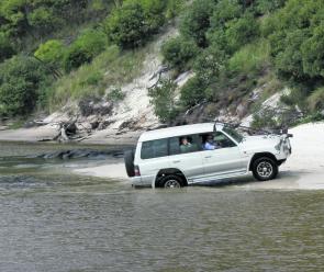
In creek crossing, points of entry and exit can be as important as the creek itself.
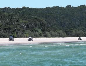
Vehicles travelling in convoy are typical on the western beach.
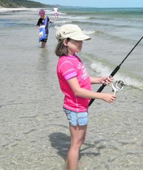
The calm waters of the western beach are great for kids learning to fish – and results are almost guaranteed!