If all goes according to plan, this month should see weather and seas starting to settle down along Fraser Island’s ocean beach. Unless of course, La Nina has other ideas…
Since the floods and cyclones, the inshore waters have been very discoloured. This phenomenon comes and goes and no one seems to know with certainty what causes it. It could possibly be the influx of flood water, or prolonged rough conditions, perhaps changes in ocean currents, or maybe changes in the planktonic life in the ocean. Who knows?
Regardless of the reasons, how it affects the fishing is of more interest to the angler. Of the common beach species, dart are probably the most affected. They appear to be reluctant to come into the turbid water; this is probably due to them being dependent on sight in seeking out food, rather than on their other senses.
The same can be said for tailor, although we are well aware that this fish will be drawn into a feeding area by the scent of baitfish or by pilchard baits being broken up by other fish.
Whiting and bream are generally more at home in dirty water and are well equipped to find food in these conditions, so these species should still be available. When the discoloured water is due to rough conditions churning up the inshore waters and dislodging beach life, bream will not be far away. Latest signs indicate that water clarity is improving and make April a month with all beach species firing.
Last year in my column, I featured a few of the western beach alternatives; particularly useful when strong inshore winds make fishing the ocean waters difficult. These involved some of the estuaries and beaches between Moon Point and Woralie Creek. There will be more of these this year.
This month I would like to revisit one on my favourite parts of the island. Back in 2003 when I was covering both Hervey Bay and Fraser Island, I wrote about the Deep Creek to Ungowa stretch of the western coast, more from the standpoint of boat anglers venturing out from mainland ramps. This time, I am thinking more of holiday-makers on the ocean beach who would like to do the trip across; maybe for some serious fishing, maybe to enjoy the sights or maybe a bit of both.
I am suggesting a round trip that can start from either the beach near Dilli Village or from Eurong. Don’t under estimate the inland roads (tracks) of Fraser Island. Their conditions vary from occasionally good to mostly difficult. The speed limit on the tracks is 30km/h but realistically you won’t be getting anywhere near this speed on many of these roads. To traverse most cross-island tracks comfortably, you need to allow at least an hour. You will need a genuine off-road 4WD with all the gears.
For this trip we will leave the beach just south of Govi Creek (originally known as Second Creek), passing Dilli Village and following the signs onto Dillinghams Road. Until sand mining along the southern part of the island ceased in 1977, this road was well maintained and used to transport minerals across the island. The road ends at the cliffs near the site of a now dismantled wharf, just south of Buff Creek. Here the main channel of Great Sandy Straits has cut into the coffee rocks forming deep ledges and some of the most inviting fishing country imaginable. These great looking features extend from a point about 500m south of here to Ungowa, 2km south. Accessibility to the water’s edge is limited. Just a few metres north is a cutting that extends down to the water, near the entrance to Buff Creek. Before Woongoollbver Creek was deepened and opened up as a major landing point for vehicular barges, Buff Creek was used by barges operated by Sid Melksham and Noel Mathison.
As might be expected, this great looking stretch of water is home to a huge variety of species. From the rocks at Buff Creek you can expect bream, javelin, jew, Moses perch and flathead. Barramundi are also available but these are more common around the many fallen timber snags between the wreck of Ceratodus and Ungowa. Just when I thought I’d seen it all, on one trip there were guys using 3-4m surf rods and pilchards, nailing big tailor, casting well out into the channel!
I need to be totally up front by saying that the best fishing here is not in the middle of the day; early mornings and dusk periods provide the best opportunities. However it would be rare for experienced anglers not to get a feed in a short time. Dense schools of hardiheads often mill around the rocks and can be cast-netted easily. Lightly weighted hardies worked along the ledges and into the eddies work well. WA pilchards used as halves, or whole, will also bring results. Artificials, particularly hardbodies running at 2-5m, and a wide variety of plastics provide rewards.
A little further south there are tracks, partly overgrown, that lead to the head of Deep Creek. This is a popular campsite as well as being another point of access for anglers. At low tide it is possible to work the shallows between here and the Ceratodus, as well as the deep ledges, and you can expect whiting and flathead. When the bigger tides flood the creek, it isn’t difficult to score big bream around the snags and mangroves.
As a point of interest, Ceratodus was a steel barge built in Scotland in 1898. She saw service as a sand barge before being discarded at her present resting place.
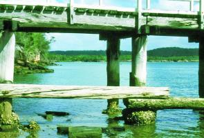
On our round trip, the next stop will be Ungowa at the northern end of this fascinating stretch of Fraser Island’s west coast. Set high on an overlooking hill, are the buildings that were the headquarters of the timber industry until it came to an end in 1991. Since then the site has been used by National Parks. The remains of a short jetty and boat ramp also serve as reminders of the logging industry. The jetty not only served this industry but for many years was a jumping off point for island tourists. Before being taken over by vehicular barges, launches such as Island Queen and Philanderer made the journey from Urangan to connect with buses to the ocean beach.
Before the jetty was condemned it was a top fishing spot with all the species being available. North of the jetty deep rock ledges provide strong possibilities but, with strong tidal run, the best fishing is usually over the bottom of the tide. There is an established camping ground with amenities not far from the old jetty.
Between the jetty and Ceratodus, the shoreline is littered with snags; the remains of trees fallen in as a result of erosion. Not the easiest shore to access but worth the effort just to get a line in amongst some of those snags.
Before leaving this great stretch of Fraser’s west coast, it should be noted that sandflies are particularly savage here in most conditions.
Heading back to the ocean beach we take the Ungowa Road north towards Central Station. There is a turn-off about 3-4km north of Ungowa that takes you directly to Central Station. Alternatively you can skip the turn off and continue on to the Woolgoolbver Creek Road, then on to Central Station.
For those who have been too busy fishing and not had time to visit Central Station, a stop here is highly recommended. There are excellent facilities as well as shady picnic areas and the shady stroll along the crystal clear creek should not be missed. A sort drive down the one-way road soon has us back at the beach at Eurong.
Back on the ocean beach and probably just in time for a late afternoon or early evening spot of fishing. Hopefully a great end to the day!
1
South towards Deep Creek, through the remains of the old Ungowa jetty.
Mud Map:
Ungowa
Reads: 5748